
Welcome to Montrose Surveying Quality land surveying services
Surveying Brooklyn | Manhattan | Queens |Bronx
Ph: (718) 849-0600 | Fx:(718) 849-0401
Surveying Brooklyn | Manhattan | Queens |Bronx
Ph: (718) 849-0600 | Fx:(718) 849-0401


Montrose Surveying Co., LLP and its predecessor firms have been supplying surveying services in New York City since 1876. Surveying is our only business. We have no other priorities or distractions.

MSC practices only within the boundaries of the City Of New York. Our office is located here; we have staked our future on the city's well being and continued growth.
Our staff's credentials are notable academically and in experience. In fact one of our partners has received the appointment of "City Surveyor" from the mayor of the City of New York. This honor is limited to New York State licensed Land Surveyors who are recognized as having expertise beyond the state license requirements.
Over 3 decades under its present management, MSC has become a firm of unusually balanced capabilities. These capabilities include:
MSC is intimately familiar with the many diverse monuments and mapping histories of the various neighborhoods in the City of New York. Sensitivity and knowledge of monument anomalies because of their affect on property and street line determination is crucial in the conducting of high-quality dependable surveys within the City of New York. This knowledge and sensitivity comes from both day-to-day exposure over years of professional practice and from the ability to review the analysis and judgment of prior practitioners in our survey record library.
MONTROSE SURVEYING CO., LLP. ESTABLISHED 1876 RECORDS OF: B.G. MEINKHEIM C.S. L.C.L | SMITH C.S. C.U. POWELL C.E., C.S. | NATHAN CAMPBELL C.E., C.S. | A.U. WHITSON C.E., C.S. | C. STIDOLPH R.A., L.S. | WHITSON & POWELL INC., P.E., L.S., C.S. | G. WEBER L.S., C.S. | WILLIAM L. SAVACOOL C.E., L.S., C.S. | KELLER & POWELL P.E., L.S., C.S. | FRED J. POWELL P.E., L.S., C.S. | LOUIS MONTROSE C.E., L.S., C.S. | LOUIS DORNHOEFFER P.E., L.S., C.S. | COUNTY SURVEYING SERVICE L.S. | CHARLES E. RANHOFFER L.S. | NOYES PALMER L.S. | CHARLES J. DEARING L.S.,C.S | GEORGE C. HOLLERITH L.S., C.S. | PETER C. HANSEN L.S., C.S.

Our licensed staff has a total of more than 65 years of surveying experience exclusively within the City of New York and are therefore, acutely sensitive to, and knowledgeable about, the subtleties of surveying in New York City.
Some of our field surveyors are capable of independently producing AutoCAD drawings and all are capable of operating the data collectors used to obtain field data. We put great emphasis is put on cross training, affording us great flexibility in staffing.

MSC takes great pride in our accomplishments. We are acutely aware that, no one of these capabilities assures the delivery of high quality and dependable surveying services, but we are certain that the absence of any of them will certainly preclude it.
We expend great effort in the pursuit of keeping these capabilities balanced and strong. Through years of experience, MSC is able to integrate these capabilities, permitting the conducting of high-quality, dependable and accurate surveys. Our mix of work incorporates all types and sized surveys.
Saeid Jalilvand, L.S., C.S. (partner)
Robert Castillo, L.S. (partner)

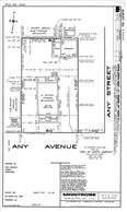
Title/Asbuilt Survey:
A Title/Asbuilt Survey is used in the transfer of title of a real property. The survey shows the boundary of the property with deed references, structures and improvements located on the property, and along the boundary, ie: fences, walls, hedges, sheds, building and encroachments of improvements beyond the property lines. The Title Survey also includes easements, right of ways and indication of adverse possession.
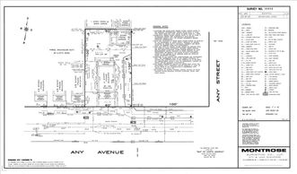
ALTA/NSPS Survey:
ALTA/NSPS is a Title Survey meeting the requirements of ALTA/NSPS guidelines and survey procedures.
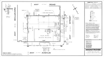
In addition to the information shown on the Title Survey, Architectural | Topographical | Street Surveys include ground topography; roadway and sidewalk improvements; utilities above and below grade and all the necessary information to be used by architects and engineers for the designs of new structures, and filing with the appropriate city agencies, ie: Building Department, DEP, Etc.
Stakeout Survey:
This Survey is for staking (marking) buildings and property lines before the structure is built. Building Stakeouts are used for the layout of buildings establishing the location and height for future construction.
Foundation Check Survey:
This survey is performed after completion of foundation to ensure the accurate location and height of foundation walls.
Axis Lines / Anchor Bolt Layout
Boring Location
Pile Layout / Location
Final Survey / Certificate of Occupancy:
Survey prepared for building department indicating the location of new improvements for compliance with the approved plan
Flood Elevation Certificate & LOMA
Settling Study
Condominium Plan Submittal:
Preparation of condominium floor plans for tax department lot subdivision
Accident Survey
Expert Testimony / Court Appearance
Surveys using GPS
Surveys for FAA Application
Preparation of Legal Description
Subdivision Surveys/ Area Calculations
Grave Layout
ULURP Application Maps
Alteration Maps
Damage Maps
Acquisition Maps
Water Grant Application Maps
Title Survey example

Architectural Survey Example

Stakeout Survey Example

Topographical Survey Example

.jpg/:/cr=t:19.17%25,l:0%25,w:100%25,h:76.92%25/rs=w:388,h:194,cg:true)